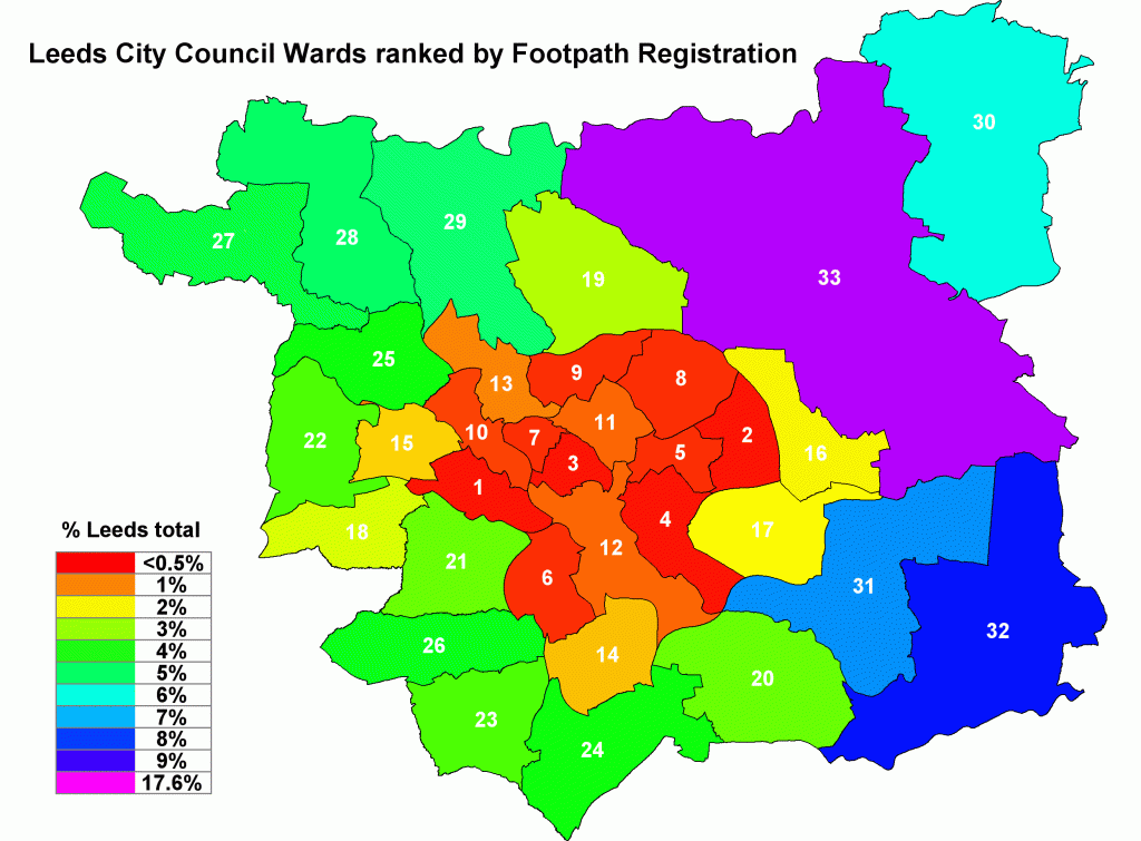
Leeds is a two-speed city so far as public footpaths are concerned. The map below shows the progress with footpath registration as Public Rights of Way in each Leeds City Council ward. Scroll down or click here to see how you can do your bit.

We have plotted the total length of registered footpath in each ward on a rainbow scale. Areas with very poor registration are bright red. Improving results run through orange, yellow, green to very good registration, which is bright blue. This information has come from Leeds City Council footpath officers. Harewood Ward is anomalous: this single ward with only 3% of the Leeds population contains 18% of all the registered footpaths in Leeds. The next highest is Kippax with 8% but most of the wards in central Leeds are scraping the barrel with a fraction of 1% of the Leeds total. We have ranked the wards in numerical order: Armley (1) is worst-off, with less than 1 km of registered footpath, compared with Harewood (33) best-off with 153 km. Harewood is so far ahead of the pack that it doesn’t sit easily on our rainbow scale, so we have coloured it purple to make it stand out.
| rank | ward | km | rank | ward | km | rank | ward | km | ||
|---|---|---|---|---|---|---|---|---|---|---|
| 1 | Armley (most deprived) | 0.9 | 12 | City & Hunslet | 7.3 | 23 | Morley South | 31.5 | ||
| 2 | Killingbeck & Seacroft | 1.5 | 13 | Weetwood | 9.7 | 24 | Ardsley & Robin Hood | 36.0 | ||
| 3 | Hyde Park & Woodhouse | 2.3 | 14 | Middleton Park | 13.7 | 25 | Horsforth | 36.1 | ||
| 4 | Burmontofts & Richmond Hill | 2.3 | 15 | Bramley & Stanningley | 15.4 | 26 | Morley North | 39.1 | ||
| 5 | Gipton & Harehills | 2.4 | 16 | Cross Gates & Whinmoor | 17.3 | 27 | Guiseley & Rawdon | 41.4 | ||
| 6 | Beeston & Holbeck | 2.6 | 17 | Temple Newsam | 18.2 | 28 | Otley & Yeadon | 44.9 | ||
| 7 | Headingley | 3.4 | 18 | Pudsey | 21.4 | 29 | Adel & Wharfedale | 45.4 | ||
| 8 | Roundhay | 3.8 | 19 | Alwoodley | 24.0 | 30 | Wetherby | 53.2 | ||
| 9 | Moortown | 4.1 | 20 | Rothwell | 29.0 | 31 | Garforth & Swillington | 63.5 | ||
| 10 | Kirkstall | 4.8 | 21 | Farnley & Wortley | 29.4 | 32 | Kippax & Methley | 72.4 | ||
| 11 | Chapel Allerton | 6.9 | 22 | Calverley & Farsley | 31.0 | 33 | Harewood (least deprived) | 153.0 |
This isn’t because the inner city has no off-road footpaths: poor registration is a major cause. Armley (for example) has over 21 km of claimed public rights of way that have never been registered. There are 374km of claimed, but unregistered footpaths, city wide. On 1 January 2026 all these unregistered paths will lapse. Landowners will be able to shut the gates, fence them off, or build on them, and people may no longer be allowed to walk where they walked before.
But this isn’t all about poor registration. We have been doing a detailed survey of local footpaths in Kirkstall Ward for the Neighbourhood Plan. It turns out that there are well-used footpaths that haven’t even been claimed, let alone registered, and many more places where the Council could create delightful new footpaths which do not presently exist. We are sure that this will also be true of other wards.
Off-road public footpaths are important because they provide opportunities for gentle exercise in a traffic-free environment. This brings major cardiovascular and mental health benefits. It is particularly important in view of current evidence about poor air quality, road traffic pollution, nitrogen oxides and the like. All age groups need more exercise, and they need somewhere nice to do it. Walking is not expensive, but public footpaths should also be convenient, attractive and near at hand.
When public footpaths were first registered in the years after the second world war, for some inexplicable reason the whole of the old Leeds County Borough was omitted from these surveys. It is now called the excluded area. Outlying towns like Horsforth, Otley, Pudsey and Wetherby were all surveyed, but inner Leeds has never been done.
This has resulted in a massive backlog affecting the inner city areas. Now the clock is ticking: unless we get these paths registered by 1 January 2026 they will all lapse. Landowners will be able to gate them off, build on them, exclude the public, and there will be nothing that we can do afterwards to reverse the switch. At the present miserable rates of progress this job will not be finished on time. Not even nearly finished. Substantial effort is needed, and the time to do it is now.
There is overwhelming evidence that regular moderate exercise is the key to good health. For the average person, exercise is far more cost-effective than hospitals, surgery or drugs. This is hardly rocket science and it is hardly new. The ancient Greeks knew about it, 2,500 years ago. One of the best gifts that we could give Leeds residents is a city-wide network of parks and public footpaths, so that everybody has an opportunity for enjoyable physical recreation at an affordable cost.
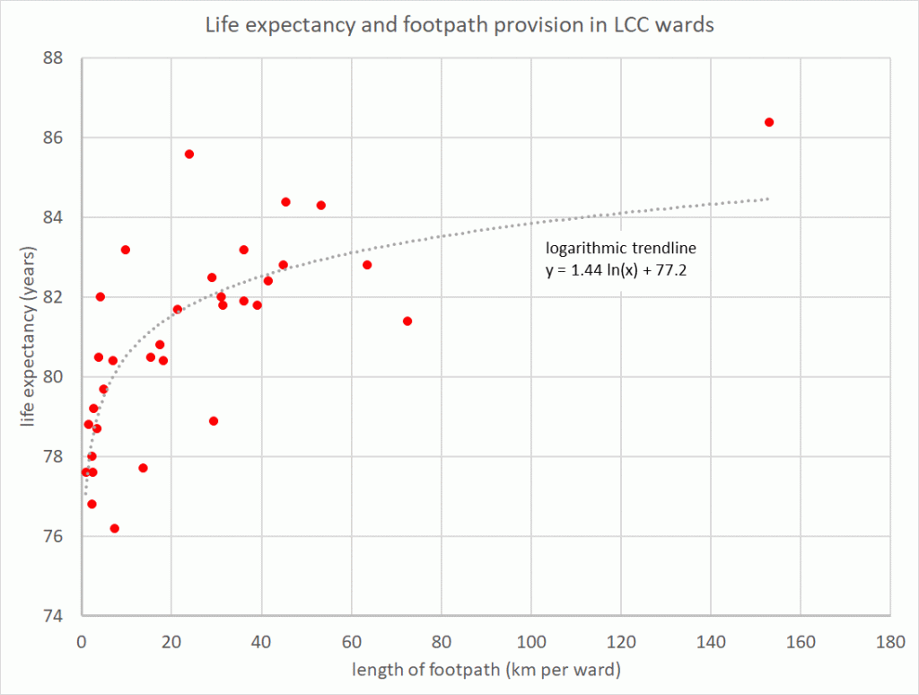
The graph below plots life expectancy against footpath provision in each of 33 Leeds City Council wards. The correlation here is probably fortuitous – both variables are tracking disposable income – but if we could monitor individual physical activty there would be a strong correlation with lifespan and health.

New footpath registration
- Public footpaths are normally open only to walkers
- Public bridleways are open to walkers, horse-riders and pedal cyclists
- Highways Act 1980 & Countryside and Rights of Way Act 2000 are the key legislation
Most existing footpaths in Kirkstall haven’t been properly registered, and some haven’t even been claimed. We are trying to speed up registration, but we need your help. One method is to show that footpaths have been freely used for the last 20 years. There is an interactive map on the Council website which shows the current position. If you have ever walked on unregistered or unclaimed footpaths, even if it was a long time ago, please send your evidence to Leeds Footpath Officers, who can use it as part of the registration process. One person’s evidence will not be sufficient on its own, but if 20 people provide written evidence, collectively covering 20 years use, then registration is very likely. Here is the way to do it:
Please click here to download these instructions as a PDF. Save them and print them out, because you will need to refer to them after they have vanished from your screen.
First Visit the Public Rights of Way pages on the Leeds City Council website. There is a lot to read here, and many other links for visitors to follow. Click the link near the middle of the screen marked “Definitive map and statement“.
Second Once you are on the Definitive map page, open the Council’s interactive footpath map by clicking the link to the Leeds public right of way map near the top of the page. (Alternatively, you can click the link in this paragraph which should take you to the same place.) Click the checkbox on the legal agreement to accept the Council’s terms and conditions, then click “OK”. This right of way map is very similar to Google maps. You can drag it across the screen with a mouse, shrink and zoom to view your area of interest. Black routes are definitive, and green routes are claims.
Third Locate the Microsoft Snipping Tool or its equivalent in other operating systems, such as Mac or Android. The Council insists that every witness statement includes a map, so we can all be certain that we are discussing the same stretch of path. We need an easy way to paste extracts from the footpath map into our statements. Fortunately, Microsoft has already provided the ideal tool as part of Windows, and it is free. We must discover where they have hidden it, because it isn’t always stored in the same place.

On a reasonably modern Windows laptop or desktop, just type “Snipping Tool” into the Search box near the start button. The computer will find it and pop an icon on the taskbar. You can pin it there, or move it to your desktop, or put it where convenient. You can download a very similar App for mobile phones and Macs. On older computers the program is still there, but it takes more finding. Look in “Accessories” or hunt in C:\Windows\System32 for a program file called SnippingTool.exe
Snipping tool allows users to draw rectangles or freehand curves anywhere on their computer screen, copy whatever is enclosed by their drawing, then save it as an image file or paste it directly into a document. In our case we can copy extracts from the Council’s footpath map and pop them into our witness statements. This is a lot easier than drawing your own map.
Fourth Send an email to the LCC Public Rights of Way Manager, Bob.Buckenham@leeds.gov.uk saying where you walked and when you did it. You can also phone the team on 0113 395 7400. You must confirm that there was no significant barrier to human access, you didn’t need to ask permission, and nobody tried to stop you. Paste in the relevant map extract and ask for this area of land to be added to the definitive map. Encourage others to do the same.
If your route is completely missing from the Council website, then you must tell the footpath officers that this is a new claim. You will need to mark it on your map snippet, using another free Windows program, such as Microsoft Paint. There are many such unclaimed routes, including one obvious path through the Kirkstall Valley Nature Reserve, along the south bank of the river. It has been in existence to our knowledge since 1993, when the Nature Reserve was established. Thousands of people have used it. It has had well over 20 years use, so time is up. Why not be the first person to register it as a new public footpath?
